4 Day Hikes to do in Sedona, Arizona
10 minute read
Sedona has so many hiking trails, really nice off-grid camping, lots of hotel and restaurant options, and so much to see and do no matter what time of year you visit! You could spend a few weeks in Sedona and still only scratch the surface of all of the nearby hiking trails. Here are 4 day hikes to do in Sedona, Arizona that you don’t want to miss!

There is no such thing as a bad hike in Sedona! You are surrounded by red rocks everywhere you look and the beautiful views never get old! Almost all trails within Sedona require a Red Rocks Parking Pass in order to park at the trailhead parking lots. It costs $5 a day or you can get a weekly pass for $15 or an annual pass for $20. There are automated ticket machines at most trailheads to purchase a pass on site.
If you have the Annual National Parks pass it works in lieu of the parking pass! Just make sure to hang it up in your vehicle before leaving for your hike.
Remember to leave no trace while hiking in Sedona! Pack out what you pack in while hiking (including all trash and food) and stay on marked trails to not disturb the sacred areas within Sedona.
Hiking in Sedona is beautiful in the spring and fall. Days start and end with slightly chilly temperatures but are full of warmth and sunshine in between. If you choose to visit in the winter keep an eye out for snow because although rare it definitely happens. During the colder months Sedona is often nicknamed “snowdona” and the contrast between the white snow and red rocks is amazing!
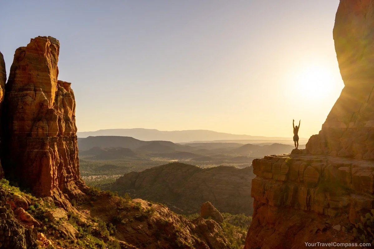
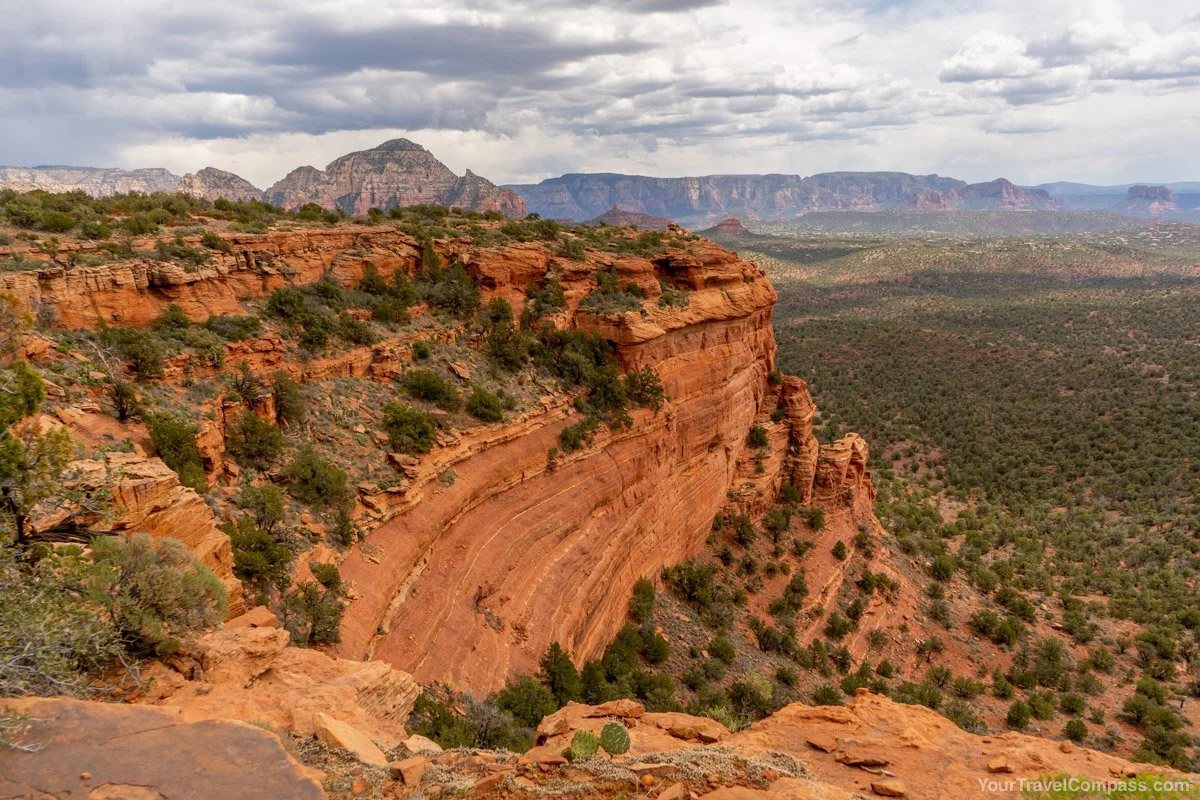
Boynton Canyon Trail
Length: 6 miles out and back
Trailhead Coordinates: 34.907640, -111.849060
Parking: There is a small lot at the trailhead with a bathroom. If the lot is full there you will see street parking nearby.

Boynton Canyon is a beautiful hike to an amazing viewpoint looking out into the canyon. It’s about 3 miles to the end with an elevation gain of about 800 feet. It’s mostly flat for the first 2 miles and then goes uphill throughout the last mile as you hike higher to the top lookout.
The first section of the trail follows the red rocks. The path becomes thinner with bush on either side and then goes through a forested area. This area in particular is nice and shady if you’re hiking on a hot day! The last stretch is hiking up some larger rocks until you get to the top viewpoint!
Once you reach the top and are facing out towards the view there is a small path to your left. If you follow that path you can get even better views! Follow the path up the rocks out onto the large, flat red rock that you can see from the summit. The path wraps around the corner and offers even more amazing views once you get there!
It’s a little bit of a climb but there is also a small cave area around the corner! You can sit in the shade and enjoy the incredible views while you rest up for the hike back!
Since this hike is longer definitely make sure to bring water and snacks! The top is a great spot to stop and have lunch.
How Long Does Hiking Boynton Canyon Take?
You want to give yourself at least 3 hours to hike up to the top lookout point depending on how fast you hike and how long you spend up at the top! Alternatively you could hike partway, enjoy the surrounding red rocks, and then turn around if you don’t want to hike all the way to the top.
Cathedral Rock Trail
Length: 1.2 miles out and back
Trailhead Coordinates: 34.825170, -111.788620
Parking: There are two small parking lots with a bathroom in the middle. These lots fill up fast so definitely get there early! Sometimes the road to the trailhead is blocked off entirely when it’s particularly crowded. When that’s the case you can take a shuttle to the trailhead.
This is one of the most well known trails in Sedona! Because it’s so well known it can be particularly hard to find a parking spot so if you’re looking to visit for sunrise or sunset make sure to get there early and give yourself time to park!
Cathedral Rock isn’t a long trail but it goes up almost 800 feet in elevation almost immediately so don’t underestimate it! It requires scrambling over some pretty steep rocks so wear hiking shoes to give your feet more grip especially when heading back down!
The main most popular viewpoint will be right in front of you to the right when you arrive to the end of the trail. You will likely see a small (or not so small) crowd of people enjoying the scenery. There is a small flat walkway to the right that you can walk out on to take some amazing photos! It looks scarier than it is but only do it if you feel comfortable.
There is also a small trail to the left of the summit that continues up to another beautiful viewpoint! It is steep and can be slippery so only continue if you feel comfortable. At the top are the tall rocks that you have probably seen in pictures when you look up Cathedral Rock!
If you hike this trail for sunset make sure to bring a headlamp! It’s too steep to try to use your phone flashlight while hiking and going down at the same time!
How Long Does Hiking Cathedral Rock Take?
About 1 hour is reasonable to hike up to the top of Cathedral Rock. Hiking back down will likely be quicker but if you’re doing it in the dark make sure to take your time and don’t rush! Also, definitely bring a headlamp!
Doe Mountain Trail
Length: 1.5 miles
Trailhead coordinates: 34.893270, -111.864990
Parking: The parking lot is shared by Doe Mountain Trail and Bear Mountain Trail so it fills up fast! There is parking along the street as well.
If you’re looking for a shorter hike that still has incredible views then Doe Mountain trail is for you! It is one of our absolute favorite hikes in Sedona and we go every time we visit. It’s about 0.7 miles up to a large plateau that you can explore as much as you want! The trail is wide open and gives you views looking across to Bear Mountain.
One of the really cool things about this trail is you can make it shorter or longer depending on your ability level and how far you feel like going. From the top plateau you can see Bear Mountain, Boynton Canyon, and then from the back side you can look over all of Sedona!
If you only have time for 1 hike while visiting Sedona, Doe Mountain is a great option! It’s not too long but packs in some absolutely stunning views.
How Long Does Hiking Doe Mountain Take?
Give yourself about 1 hour to hike up the top! If you can it’s a great trail to hike up and watch sunset!
Subway Cave via Boynton Canyon
Length: 4.8 miles out and back
Trailhead coordinates: 34.907640, -111.849060
Parking: Parking is at the Boynton Canyon trailhead.
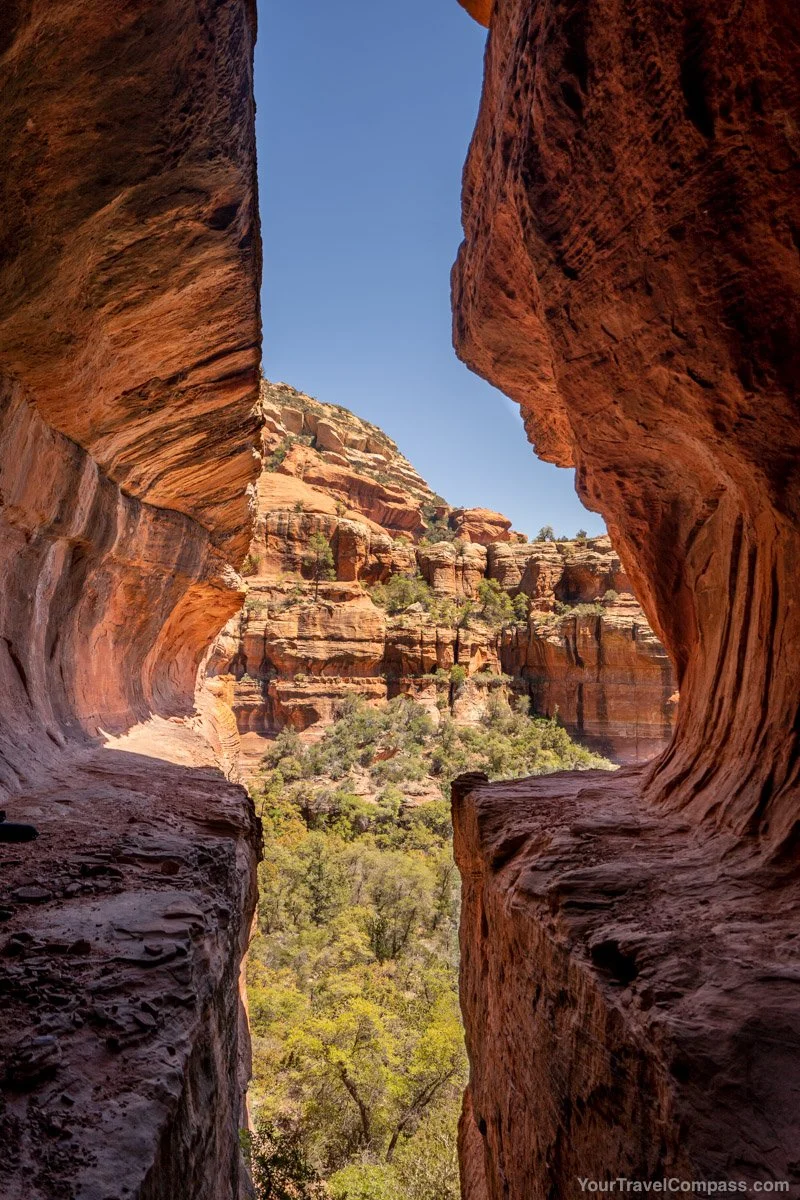
Subway cave is a really cool cave that can be accessed via the Boynton Canyon trail. Hike about 2 miles along the Boynton Canyon trail until you get to a slight divide where the main trail continues straight and a small trail goes slightly to the right.
The easiest way to find the Subway Cave is to download the Alltrails map for the hike. On the map you can see a small trail that continues about 0.4 miles to the cave. The last section involves climbing up steep rocks to get to the entrance of the cave but it’s so worth it!
Even though it’s close to Boynton Canyon it’s a much different perspective than from the top because you’re a lot lower. If you have time it’s worth checking out both trails.
How Long Does Hiking to Subway Cave Take?
From the trailhead it’s about 45 minutes to hike to the cave depending on how fast your hiking and how many times you stop. The cave itself isn’t too big so if there are other people there isn’t a lot of extra room.
Other Hikes to Consider if You Have More Time in Sedona
There are so many hikes to choose from in Sedona that if you have more time consider trying one of these:
Devil’s Bridge - this is another very well known trail! Most people park at the Dry Creek Vista Parking area and begin hiking from there. If you have a 4x4 vehicle you can drive in to the official trailhead. You definitely need to get there early otherwise you won’t be able to find a parking spot. The unique arch creates what looks like a bridge and it’s beautiful! But if you want to experience it without waiting in a line of people go early in the morning!
Birthing Cave - this 2 mile out and back trail opens up to give you expansive views from the cave. This is considered a sacred area so be respectful by leaving no trace and not disturbing the area.
Bear Mountain Trail - this trail starts across the street from the Doe Mountain trail. It’s 4.9 miles out and back with an elevation gain of over 2,000 feet so be prepared for a hard hike up! But the 360 degree views at the time are incredible!